
Read the longitude and latitude
If the geographical position of a place has to be given, there are several possibilities. One is the indication of the longitude and latitude. Learn how to best read them.
What you need:
- Atlas
If the location of a place has to be specified, this can be done via the geographical location Conditions such as rivers, lakes or mountains happen or also on the basis of large cities and National borders. But reading the longitude and latitude is a method that is always possible.
Read off the longitude
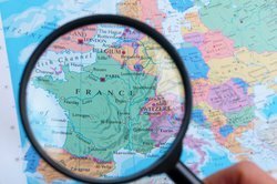
- Look for the location in an atlas whose location you want to specify precisely. Note that the map should show both latitude and longitude.
- The lines of longitude run from the north to the south pole. This means that they run from top to bottom on a map. Now look for the longitude that runs through the place you are looking for.
- Follow this longitude to the top or bottom. lower edge of the map and read off the number of degrees.
- If there is no direct longitude running through your location, consider the degrees of the two longitudes that are to the right and left of the location or area. The exact number of degrees can now be agreed.
- When entering the final degree of longitude, always make sure to state whether it is western or eastern longitude. The prime meridian is defined by the Greenwich observatory.
Geographical location - definition
Geography deals with the location of countries, rivers, seas and ...
Determine latitude
- The latitude runs parallel to the equator. On a map, latitudes are the lines that run from right to left. Find the lines that are closest to the appropriate location.
- You can then read off the degree of latitude on the edge of the map. Not only the number of degrees is important, but also whether it is north or south latitude. These designations indicate whether the place is north or south of the equator.
How helpful do you find this article?